Best Utah National Parks Itinerary from Las Vegas
Takeaways
Opportunities for heart pounding adventure and quiet reflection in nature will present themselves at every turn during this Utah national parks itinerary from Las Vegas.
The “Mighty 5” national parks in Utah are Arches National Park, Bryce Canyon National Park, Canyonlands National Park, Capitol Reef National Park, and Zion National Park. Each one offers visitors something new to see and explore, from sweeping canyons and monuments to red rocks and alpine forests, all working together to create the breath-taking landscape of the Colorado Plateau. Follow along for ideas on planning the best Utah national parks itinerary from Las Vegas!
Best Utah National Parks Itinerary from Las Vegas
The McCarren International Airport will serve as your gateway to Utah’s National Parks, allowing visitors the opportunity to spend a few days in Las Vegas before leaving the neon lights behind in exchange for twinkling stars and moonlight. The diverse landscape among the five national parks, linked by remote scenic drives and numerous state parks, will transport you to a world that feels far away from the glitz and glamour of Las Vegas. Opportunities for heart pounding adventure and quiet reflection in nature will present themselves at every turn during this Utah national parks itinerary from Las Vegas.
Zion National Park
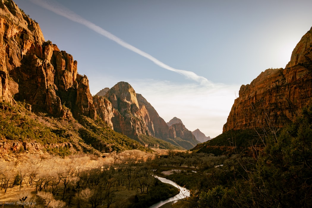
The closest national park to Las Vegas, Zion National Park is the first stop on your Utah national parks itinerary from Las Vegas. Zion means “the Promised Land” in Hebrew and this iconic park certainly lives up to its name. Located only 168 miles from Las Vegas, Zion National Park is most well-known for the expansive Zion Canyon, a gorge reaching depths of almost 3,000 feet in some areas. Along the canyon are a multitude of opportunities for hiking, horseback riding, canyoneering, and rock climbing. There are two scenic routes to take through the park, each offering distinctive sites and scenery.
The Zion Canyon Scenic Drive is home to the most well-known sites of interest in the park. From mid-March through November, there is a complimentary shuttle bus that takes visitors on an approximate 8-mile route through the park, with several stops along the way. During this time, car traffic is disallowed on this stretch of road. The Human History Museum will be one of the first stops, telling the cultural history of Zion through interactive displays and a large model of the park. The permanent collection of items at the museum includes American Indian artifacts and exhibits illustrating the path from pioneer settlement to creation of the park. Rangers are on hand to answer questions and offer advice for your time in the park.
Experienced hikers will want to set off on the narrow trail to Angel’s Landing, offering one of the best views of the surrounding Zion Canyon, while hikers of all abilities will want to experience at least some time in The Narrows. The narrowest section of Zion Canyon, with many portions completely within the Virgin River, is hailed as the quintessential Zion experience. Guided tours are available and are recommended for beginners or those unfamiliar with the surrounding area.
Another popular hiking spot in the park is the Emerald Pools area, offering trails suitable for families that can accommodate strollers and wheelchairs, to strenuous trails at higher elevations. There are three levels of pools, Lower, Middle and Upper, amid the trails, each a bit harder to get to than the last. All trails will offer fantastic views of brightly colored mesas and buttes, dotted with clumps of green trees.
A short walk from the shuttle along the Weeping Rock Trailhead is an alcove under a sandstone bowl, formed by water erosion, with water seeping from the rock forming hanging gardens and anything from a slow trickle of water to a rushing waterfall, depending on the season and level of recent rainfall. The Riverside Walk, a paved trail that follows the Virgin River, leads through more hanging gardens and waterfalls, and is home to an array of birds and wildlife.
At the east entrance/exit of Zion National Park, is the Checkerboard Mesa, a white colored plateau with a distinctive checkerboard pattern surrounded by cliffs covered in white and amber striations and swirls. The nearby town of Springfield is the best place for gathering supplies and booking guided tours. Courses and equipment rentals for canyoneering are available just about year-round, and horseback riding tours along the Virgin River can be booked from March through October.
The Zion Mount Carmel Highway is the second major route through the park. Running across the park in a southeastern direction above the valley, cooler air can be enjoyed in the higher elevations as the road winds along the side of the cliffs and through a very narrow tunnel through the stone. There are no shuttles along this route, but there are many overlooks, including some along the popular Canyon Overlook Trail, an easy one-mile round-trip hike through towering pine trees.
With the Zion Mount Carmel Highway offering a parallel experience to the Zion Canyon Scenic Drive, and with so many unique sites to explore between the two, you will want to devote at least two days during your Utah national parks itinerary within Zion National Park. From Zion, you will travel approximately 86 miles to Bryce Canyon National Park. Consider a detour along the Valley of Fire Scenic Byway through the Valley of Fire State Park to see the iconic Elephant Rock, a natural sandstone arch resembling one of the massive mammals, with a unique appearance of multiple chunks of rock stacked together.
The best Utah national parks 3-day itinerary from Las Vegas would incorporate a mix of attractions and sites from Zion National Park and the next location on our list, Bryce Canyon National Park.
Bryce Canyon National Park
“Otherworldly” is a word often used to describe Bryce Canyon National Park. Full of red rocks, fabulous vistas, and pink cliffs, this national park is also home to the largest concentration of hoodoos in the world. Hoodoos are columns or pinnacles of weathered rock, generally formed within sedimentary and volcanic rock formations. These unique structures aid in creating a landscape that looks like something out of a science fiction movie. The top place to see hoodoos in Bryce Canyon National Park is along the northern section of the park along the higher regions of the Colorado Plateau.
An in-park shuttle system operates to help visitors easily reach all the main points of interest within the park while helping to reduce car traffic and its effects on the natural surroundings. The shuttle begins at the Visitor’s Center, with stops at Sunrise Point, Bryce Lodge, Sunset Point, Inspiration Point, Bryce Point, and Paria View.
The Bryce Canyon Amphitheater is one of the most convenient parts of the park to get to with the most famous structures, making it the most visited site within the park each year. Many points of interest are within the Amphitheater, including Sunrise Point, Sunset Point, Inspiration Point, and Bryce Point.
Pink Cliffs are the backdrop for famous sites like Boat Mesa and The Sinking Ship, two well-known rock formations within the park. Limber pine trees dot the landscape, with their exposed roots clinging to the eroding, tilted ground. The Queen’s Garden Trail is an easy hike leading past the Queen Victoria hoodoo towards the Fairyland Loop.
Fairyland Canyon is a scenic overlook just north of the park entrance, allowing park guests to view the hoodoos up close. After enjoying the stunning view of the valley and formations below, advanced hikers can descend into the canyon on the 8-mile Fairyland Loop. This strenuous hike winds down the canyon and through the maze of hoodoos below, before ascending to Sunset Point.
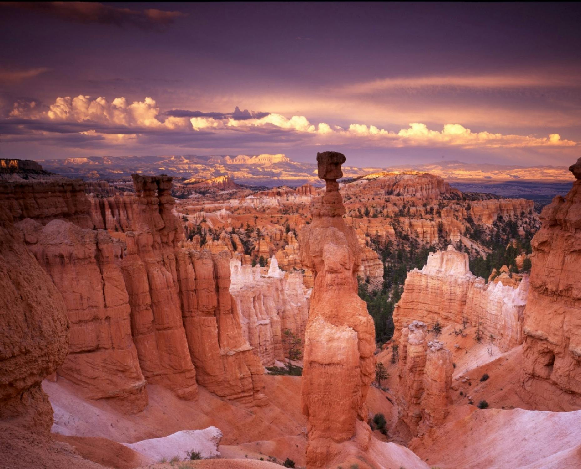
Bryce Canyon’s most famous section of hoodoos, Silent City, has its home in Sunset Point. This tightly packed maze of hoodoos is a natural marvel and example of erosion that begs to be explored and appreciated. One of the best-known hoodoos, Thor’s Hammer, can also be found here among the red, yellow, and orange hued rock walls.
For panoramic views of the entire park, a visit to Rainbow Point is in order. The famous Grand Staircase can be seen from this vista. Made of many layers of colored rocks beginning with the pink cliffs under your feet, with striations of grey, white, vermillion, and chocolate winding into the distance.
Rising more than 8,000 feet along the western rim of Bryce Canyon, Inspiration Point looks toward the Silent City hoodoos, offering another unique perspective of this well-known site. There are three different viewpoints along Inspiration Point, each higher than the last.
Next to Inspiration Point, and 200 feet higher, is Bryce Point. This higher elevation offers even better panoramic views of the hoodoos, enabling visitors to view the full Bryce Canyon Amphitheater from this outlook. Bryce Point is the best spot within the park during sunrise, as the rays of light reflect off the hoodoos, lighting the valley ablaze in warm colors.
The best place to capture the beauty of the setting sun reflecting off the hoodoos and slot canyons is at Paria View. Wildlife is abundant in this area, allowing photographers the chance to catch a grazing elk or deer, or a soaring falcon in their camera lens against the backdrop of the setting sun. This serene forest meadow is the ideal way to end a day during your Utah national parks itinerary.
Arches National Park

Located in Moab, Utah, Arches National Park is 244 miles from Bryce Canyon National Park and is the perfect addition for a longer Utah national parks itinerary of 5 days or more. Popular activities in Arches include canyoneering, ATV rides, hiking, river rafting, rock climbing, and mountain biking. The Arches Scenic Drive is a 19-mile-long road leading past some of the most popular sites within the park, beginning with the La Sal Mountains Viewpoint, offering a sweeping view of the park with the mountains off in the distance.
The iconic formation aptly named Balanced Rock is a must-see and one of the most photographed sites within the park. Sitting 128-feet above the ground, this boulder estimated to be 3,000 tons is attached to its pedestal in a natural balancing act. Balanced Rock can be seen from the park’s road, but is an easy, .3 mile walk from the parking area for a closer view.
There are more than 2,000 natural stone arches and thousands of stone pinnacles, rock fins, and red-rock formations throughout Arches National Park. Double Arch, the arch containing the tallest opening in the park, is easily visited via a half-mile hike from the road. Uniquely formed by water erosion from above instead of from the sides like most arches, the large arches share the same stone foundation, which can be climbed and walked upon for close inspection of this famous landform.
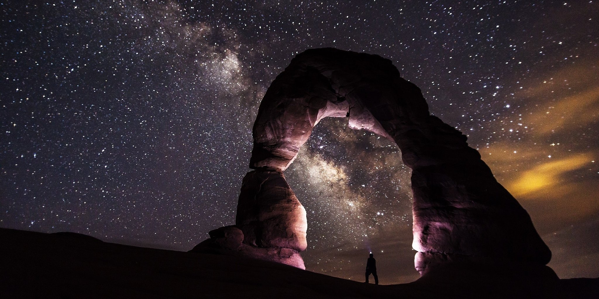
The most recognizable site in the park, thanks to Utah’s license plates, the Delicate Arch is hidden in a sandstone bowl, standing majestically alone on the expansive vista. It is a moderate hike to reach the Delicate Arch but is well worth the effort.
The Devil’s Garden Trailhead is a wide, paved trail lined with arches and a campground with 50 campsites. The most famous arch in this immediate area is the Landscape Arch, accessible via an easy hike from the Trailhead. The extremely delicate, spiderweb pattern of the Landscape Arch stands 290 feet tall and is the largest natural arch anywhere in the world.
The Fiery Furnace section of the park is full of twisting caverns, slot canyons, and gorges full of interesting rock formations like stone passageways and slender sandstone arches. Ranger guided tours steer you through approximately 2 miles of the twists and turns, pointing out interesting sites and teaching guests about the process of erosion and how it forms the landscape seen in every direction. There is no marked trail in the Fiery Furnace, so caution is advised when exploring without a guide.
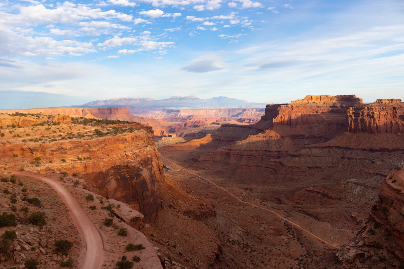
Along the way from Bryce Canyon to Arches is Capitol Reef National Park, known for cliffs, canyons, and domes, but also the Waterpocket Fold, a 100-mile-long wrinkle in the Earth formed on an ancient fault-line and giving the landscape a unique appearance that must be seen in person. Canyonlands National Park, the largest of the five national parks in Utah, is located 32 miles from Arches and is famous for its mountain biking terrain, and the Island in the Sky, a paved scenic drive on top of the 1,500-foot-tall mesa. Either of these parks would make a perfect side trip from your home base while exploring Arches National Park.
A final honorable mention to include on the best Utah national parks itinerary from Las Vegas is a quick stop at Goblin Valley State Park. Here, moving rocks coupled with erosion have left thousands of interesting sandstone shapes and rock formations all along the valley floor. These shapes resemble alien lifeforms, giving the park its name. To create the best Utah national parks 5-day itinerary from Las Vegas, choose one or two “must-do” items in each of the five national parks and a few items in between like Goblin State Park for a well-rounded experience.
The best Utah national parks itinerary from Las Vegas will take you on an adventure from the hustle and bustle of Sin City to the serenity of nature and some of the most unique scenery you may ever be surrounded with in your life. Only two states (California and Alaska) have more national parks than Utah, making it a hotspot for nature lovers and thrill seekers alike with endless options for hiking, camping, climbing, and more. With so many things to see and do, your itinerary can be customized to include a smattering of highlights, or an in-depth exploration of one or more of the treasures to be found in the almost 92,000 square miles of national parks in Utah.